


Topographic search: The strategic researcher Ibrahim Mustafa (Kaban)
Kurdistan is a historical fact, with its demographic and political stages, and its geography emerged through all the maps that talked about the Middle East, and it cannot be overlooked when we look at all the writings of historians and Orientalists, whether on the written side or on the many maps that the World Library abounds with, and until we understand closely these In fact, and before beginning to explain the maps, we will go into an understanding of several important issues through which we read the keys to this historical reality that the occupied countries of Kurdistan often try to neglect according to their agendas and policies hostile to the existence of this people who built the Middle East region and its civilizations with their great contributions.
The first understanding: Most of the information and history recorded about the Middle East are the European orientalists who, with the support of their countries, went through many exploration and intelligence missions to the region during the last quarter of the Ottoman Sultanate’s life, in order to convey an integrated picture of the demographic, political, and military nature of the region. This process facilitated, in the first place, the overthrow of the Sultanate after its weakening and transformation into a vast state that is unable to process, and the start of colonizing the region after the discovery of oil. We are fully aware that this was done through the information and maps that the security orientalists transmitted and drew. We find this clearly in the French, British and Italian missions, and later the American and German missions, although the latter focused on the commercial side.
From here, we find the focus on mapping and determining the geography of the area controlled by the Sultanate under the banner of the alleged caliphate, and through that information that was written mainly to guide the Western mandate and bring down the Ottoman occupation.
The second understanding: The fact that Kurdistan is a political map in the Middle East cannot be neglected, and its nature as an integrated and connected country according to demographic and political circumstances and data. When we review these maps, we find a focus on the reality of this country, in its recognized name, and its permanent presence in all sources, and it is no secret to anyone that the Kurdish presence took a large space in the Ottoman Sultanate, as all the sources related to Ottoman history, along with its informational and cartographic side, convey the integrated picture about The Kurdish country, and that this region witnessed many revolutions and rebellions against the Sultanate, and Kurdistan was living in a semi-independent state within the Sultanate. This is clearly evident in the middle of the maps drawn by the Ottoman historians. We understand through this that the Sultanate does not deny the Kurdish reality, despite the relentless attempts to do so, and the facts on the ground imposed on the Sultanate a large Kurdish presence in its records and maps. In addition to the Western maps that conveyed the image in an orderly manner, the Ottoman political and demographic maps in addition to the administrative documents and what related to the states and the provinces were full of a lot of talk about Kurdistan and its people, and Kurdistan was witnessing organized and constantly revolutions against the Sultanate, and this is useful in the issue of partial independence that it enjoyed. Kurdistan within the Sultanate. It is understood that the political geography of Kurdistan is not an emergency or a new concept, but rather a historical reality on the ground. Rather, the presence of the name of Kurdistan on the maps in the same formulas that came in the Arabian Peninsula, Egypt and the countries of Persia, and we will find on the maps that the clarity of the name of Kurdistan and the geographic region specified by all Maps emphasize its political importance.
The third understanding: ancient maps are full of defining the housing and geography of the Kurdish people’s presence in the Middle East, and the period of the Ottoman Sultanate was more clear to the crystallization of the idea of mapping and defining it about the demographic spread of the peoples who are distributed in the region and manage their affairs semi-independently within the sultanate’s domination, especially the maps that it drew. The Sultanate is in the hands of its historians, or Western orientalists, who have devoted long decades to understanding the nature of the Middle East, whether for intelligence or knowledge purposes. Among these major peoples in the Middle East region, the Kurdish people maintained their presence, status, and demographic and political geography, and this is clearly evident in all maps of the period between 1700-1925 AD.
Based on this awareness of the facts and circumstances that were woven into the Middle East, we realize the size and value of these maps, which are considered a treasure on which to convey the correct image of the existence of the Kurdish country, its borders, and its people. Therefore, we will find in these maps and information an accurate definition of the nature of the Middle East and its social structure, the dismantling of the Ottoman Sultanate and the rebuilding of new entities compatible with Western goals, and the new entities that were formed after the 1919 Lausanne Agreement, and that the absence of the Kurdish country from independence came as a result of the interests of the major powers with the beginning The twentieth century, who entered into direct deals with the Turks, Persians and Arabs to enable them to seize and control Kurdistan, despite their full knowledge of the reality of the Kurdish people and their country in most of the maps drawn by the orientalists, and the information that was transmitted in reports, whether security or exploration, from the Middle East through intelligence missions .
Therefore, this topographic research focuses on showing and commenting on dozens of these maps, and clarifying some aspects of them.
Map of the Ottoman control at the beginning of the year 1432

This map dates back to the beginning of the seventeenth century, and details the demographic distribution within the territories of the Ottoman Sultanate’s control. The map shows the indication of the Kurdish presence and its formation of a popular society according to the close-up image of the map. The Kurdish control was mentioned in the Turkish language thus: (Porus Curdi), meaning the Kurdish people. As well as expanding the control of this people, according to the map, to include vast areas of southeastern Turkey and northern Syria.
The map was drawn according to the sources by Atlas Coye Cosmographic Medicias de Fabrica Mundi et Fabricate Figura (Atlas of the World: Finely engraved and painted), by Jodocus Hondius based on a work by Gerard Mercator. The frame itself is important thanks to his pictorial title “Sultan Mahomet Torkurum Imperat” (Sultan Mehmed Emperor of the Turks), which was most likely intended to represent Sultan Mehmed II (1432-1482), known as Muhammad the Conqueror.
Areas of Ottoman and Safavid control after 1450

The map clearly shows the areas of sharing the Ottoman Sultanate and the Safavid state and the borders between the two parties, as it clearly shows the Kurdish region in the Ottoman-controlled region / Turkey, Syria and Iraq / Kurdistan - and under it the name Diarbekr, a metaphor for the Jami’s center for the region.
The name of the map according to the publisher "Ottoman and Persian", after 1450 AD, circa 1915. Map of empires in the Middle East during the fifteenth and seventeenth centuries: upon the accession of Mehmed II, 1451 AD, additions 1481-1683, the Ottoman-Persian frontier circa 1555. Shows Also in the eastern Mediterranean, the Red Sea, the Caspian Sea, the Black Sea, and the Persian Gulf. From "The Legacy of the Last Caliph, A Short History of the Turkish Empire" submitted.
Map source: Sir Mark Sykes. (Macmillan and Company, London, 1915). Artist Emery Walker Ltd. (Print Collector Photo / Heritage Images via Getty Images).
Map to illustrate the Mesopotamian campaign in 1919
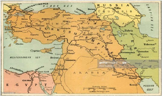
A map showing the demographic distribution of the peoples of the Middle East and the areas of power control during the First World War. The Kurdish presence appears in the name "Kurdistan /" and its spread among Turkey - Syria - Iraq - Iran, and the map indicates, according to the points drawn, the control of the three peoples "Arabs, Turks and Persians" outside the Kurdish region, where Arab nationalism spreads in the Levantine Badia, while the Turks control "the remnants of the Ottoman Sultanate." On this region, and on the other side, Persian control over the Kurdish region on the eastern side is evident.
According to the publisher, the map illustrates the Mesopotamian Expedition 1919. The Middle East Theater Show of World War I, from “History of the Great European War: Its Causes and Effects,” Volume Five, by W. Stanley McBain Knight. [Caxton Pulishing, Ltd., London, 1919]. Map Source: Artist George Philip and his son. (Photo / Print Collector / Getty Images).
Map of the Kurdish tribes in the Ottoman Empire

The importance of this map lies in a complete volume prepared by Sir Mark Sykes - the British politician and officer between the years (1879-1919), who held several positions in the British Foreign Office, attended the Peace Conference in Paris, and his name was associated with the famous Sykes-Picot Agreement in 1916. Where Sykes casts Shedding light on important aspects of the history of the Kurdish people in the Middle East in terms of demographic distribution, the region of Kurdish presence and housing extending to thousands of years in this vital region of the Middle East, especially with regard to the spread of clans, tribes, families, and the geographical area that it occupied and is still today.
Sykes showed a great interest in trips to the Middle East as part of his work in preparing the appropriate ground for British interests. His focus was on the Kurdish region, "Kurdistan" within the Ottoman Sultanate, especially as the Sultanate was taking its last breaths, and Sykes and a large number of British and French intelligence were focusing on exploring Area and assess reports and research about them for their governments. He visited Erbil, Kirkuk, Sulaymaniyah, Mosul, Bhutan Island, Van, Ararat, Sri Kaniye and other important areas of Kurdistan, and published the details of his travels in three books “Across Five Turkish States” (London 1900) and “Dar Al-Islam: A Journey Through Ten Asian States of Turkey” (London 1904) and “The Last Legacy of the Caliph” (London 1915). He also published a paper entitled “Travels in the North of Mesopotamia” (1907). As for this paper, “Kurdish Tribes in the Ottoman Empire” attached to a clear map, he published it as an appendix to his book “The Last Legacy of the Caliph.” In his long research attached to a map, we find the spread of Kurdish tribes in the Kurdish part of Syria / Rojava / and the northern part of Iraq / Bashur / as well Southeastern Turkey / Bakur / and also western Iran / Roghalat /. Sir Sykes’s research became a historical confirmation that this region is Kurdish and was free of Arab, Turkish and Persian presence, and that the Kurdish region in northern Syria was vital and important for the spread of the Kurdish people there before 1900, This refutes all propaganda, news and fake information that talk about the migration of Kurds from the Kurdish region in Turkey to the Kurdish region in Syria, because the borders that were established between the two parties after 1919 were placed on the Kurdish cities and villages that were divided between the two new entities.
In the record of Sir Sykes' maps about the Middle East, he focuses on this map in which the demographic distribution is transmitted in the year 1400 AD. All of the Syrian north and the Turkish southeast, opposite large areas of Iran and Iraq.
The Middle East between the years 1096-1099AD

A map showing vast areas of Kurdistan, where there are two large and clearly "Kurdistan /" regions, one of which is in the area between Turkey and Syria, while the second region is between Iraq and Iran, which confirms the reality of the current demographic distribution of the Kurdish people, as the reality of this presence is clear before nearly 1000 years, and with the same spread over the land of Kurdistan.
This map focuses on the reality of civilizations in the Middle East during the twelfth century: the Byzantines, other Christian states, the Abbasid Caliphate, the Seljuks, the Fatimids. Also shown is the route of the First Crusade 1096-1099, the eastern Mediterranean, the Red Sea, the Caspian Sea, the Black Sea, and the Persian Gulf. From the "Legacy of the Last Caliph."
Map Source: A Short History of the Turkish Empire. ”The presenter. Sir Mark Sykes. [Macmillan and Co., London, 1915]. Artist Emery Walker Ltd. (Print Collector / Heritage Images via Getty Images). The four, Sir Mark Sykes explains the Kurdistan region between Turkey and Syria - and a second region between Iraq and Iran in 1915 AD, that is, before the establishment of the new four entities, each of which annexed part of Kurdistan.
These maps indicate the demographic and political nature of the Middle East region before it was divided by Sykes and Picot, and of course, “Sir Mark Sykes, who was appointed by the British along with the French diplomat François George Picot assigned by the French” to divide this region according to the French and British interests, and that was a reason for dividing The geography of Kurdistan is attached to new entities, "Turkey - Syria - Iraq", after they left the fate of eastern Kurdistan and the part in Armenia and Azerbaijan to their destiny in the hands of those countries.
Kurdistan in the year 1888 AD

Map of the Levant, Turkey and Iraq in the Ottoman Era, drawn back to 1888 AD The source of the map goes back to the British Collins Press Included in the map is an illustration of the Kurdish geography that extends from central Turkey and northern Syria to northern Iraq and western Iran.
The Ottoman Empire in Asia in 1792
The reference to Kurdistan is visible on this map of the United Kingdom Army

Seutter map of the Ottoman Sultanate in 1730 AD

The demographic distribution and local control in the Ottoman Sultanate is clear from this map, as the designation of regions is a feature of this map in which the Kurds appear and their presence in vast areas, and it is what we find in all the old maps about the historical Kurdish presence in their current location, and Kurdistan was divided with the beginning The twentieth century includes four entities "Turkey - Syria - Iraq - Iran", due to the mandate and the new regional entities.
When zooming in on the source, the names of the regions and cities are clearly visible, and the attached close-up image gets a region called / Kurdistan /, and its largest city is noted in the form of the capital / Diarbekr / Photo source: (Photo: Sepia Times / Universal Images Group via Getty Images) .
The Ottoman Empire between the years 1481 - 1683 AD

A map that shows the demographic situation of the Ottoman Sultanate between the years 1481-1683AD, and this period was important for the beginning of the Sultanate's expansion in the Middle East and North Africa.
During this period, the Kurdish presence in the Middle East appears on the map, between Turkey and Syria today. Map Source: Historical Atlas by William R. Shepherd in 1923.
Kurdistan in 1826

In this map dating back to 1826, the clear division of the local states that were controlled by the Ottoman Sultanate was shown in the form of a confederation, while there were local governments on a specific geography and borders, and linked to the Ottoman Sultanate as the center, while it enjoyed complete autonomy, and administered its local governments Its affairs.
According to the publisher, the map appears showing the eastern part of the Ottoman Empire, the region’s borders and topographic features, and the Kurdistan / Iraq Al-Ajami region, Arab Iraq, and Anatolia / as well as the Levant - Syria, which was coastal areas extending to which included Lebanon and Jordan, and up to the Badia regions that The Arab tribes were active there. On the map, we find Kurdistan naming two main regions, one of them encompassing most of northern Iraq and the other between Syria and Turkey. Source of the map: Michael Maslan / Corbis. / VCG via Getty Images).
Kurdistan in 1801

Map showing the Ottoman Sultanate between the years 1801-1913 AD, by William Miller. It was published by Cambridge University Press in 1913.
The map has been rounded off to clearly show the area (KURDISTAN) that appears in the map, and its area is larger than the area of the Levant, and includes important areas of the Middle East.
The Ottoman Sultanate in 1895 AD

An original old colored stone map from 1895 AD for the regions of the Ottoman Sultanate, showing the demographic distribution of the Kurdish people under the name "KURDISTAN".
Colton's famous map of the regions of the Middle East

This map dates back to the year 1855, as it shows the demographic nature of Syria, Iraq, and Kurdistan within the Ottoman Sultanate, and it is noticed here that Syria was limited to the Levantine Badia, while Iraq was the central and southern regions under the name of Arab Iraq, while Kurdistan is located between Turkey and Syria and passes through Al-Ajami Iraq. To western Iran, and of course these entities did not exist at that time, because they were established by the French and British mandates during the first quarter of the twentieth century.
RAND-Ma Kanali & Co. Map of the Ottoman Sultanate in 1895

This map is one of the topographical references that depends on it as an important historical reference in historical sources. It was drawn during the end of the nineteenth century, as it shows the political and demographic distribution within the Ottoman power. What is noticeable in this map is the accurate description of the regions, their names, and their distribution, which makes clear the name of the Kurdistan region that lies along the eastern Mediterranean and includes large parts of the modern entities Turkey and Syria, and extends to include Kurdish Ajami Iraq to large areas of Iran. This map is best known for the RAND - McNally & Company map. It was printed in the United States of America - Chicago in 1897 A.D.
With the approximation process to the map, we will find clearly the formulation of the map for the map of Kurdistan, and this confirms the existence of Kurdistan as a political and demographic reality that cannot be denied in the Middle East.
John Senkes' map of the Middle East in 1721

It consists of a world atlas that includes 34 maps, including this one drawn by John Senkes and published in 1721 AD.
John Senex (1678-1740) was an English surveyor, engraver, bookseller, and publisher of maps and atlases. He served as the geographer to Queen Anne (1665-1714), the first Monarch of the United Kingdom (from 1707 to 1714) formed in 1707 by the Confederation of England and Scotland. Senex was elected to the Royal Society in 1728. He freely borrowed from other mapmakers, in particular from the chief French cartographer Guillaume de L'Isle.
When zooming in on the map in the source, the Kurdistan region will be found, and it includes large parts of the new entities that were established after Sykes-Picot "Turkey - Syria - Iraq - Iran".

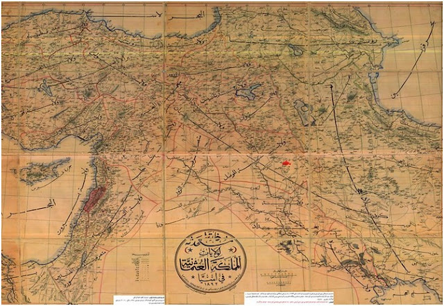
Kurdistan in the Ottoman map in 1893
The geography of Kurdistan can be clearly seen on the map, as the sharing of the existence of the components and their geography is evident from the significance of this map, which was drawn up in 1893 by the Ottoman geographers. The vast area on which the Kurdish presence is concentrated in the map extends between the four countries that were established after 1919, and this also indicates that the Ottomans used to call this region Kurdistan, and this confirms the existence of Kurdistan within a political geography.
------------------------------------------------
The method of simplified explanation and commentary on what was mentioned in the maps was taken, so that it would be smooth for the readers, and the historical facts and facts contained in the maps in the aforementioned period were the best witness to the greatness of the Kurdish people and their history in the Middle East, and thus all allegations about Kurdistan have no truth. Historical as geography, while these maps confirm the absolute truth, namely that the geography of Kurdistan at the demographic and political level was present and this has a great influence on the course of events in the Middle East before the emergence of the entities that divided Kurdistan, "Turkey - Syria - Iraq - Iran".
----------------------------------------------
Map Sources: The Library of Congress and Gettyimages
Note: It is prohibited to transfer or copy the material without mentioning the official source (the Geostrategic Network for Studies).
